
Inspiration
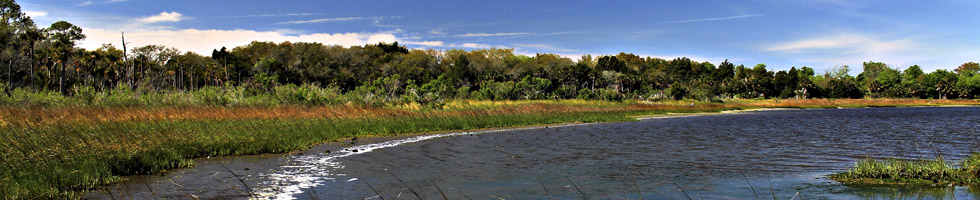
This paddling guide includes the waterways between the Nassau River and the St. Johns River in north-eastern Duval County, including the Intracoastal Waterway (ICW), Sisters Creek, Simpson’s Creek, and associated rivers, creeks, and wetlands. The small barrier islands in this area, which lie with the Atlantic Coast to the east and well-established marshes and estuaries to the west, are commonly referred to as the Florida Sea Islands. The wind, tides, and waves constantly change the shape of the islands, so that visible differences are apparent over periods of only months. These trails allow paddlers to visit diverse habitats, including islands, ocean, marshes, and estuarine backwaters within the adjacent tidal creeks and tributaries, all within a short period of time. The trails contained herein are easy to access from main roads.
These waterways, with their mix of natural waterfronts, island hammocks, tidal marshes, and pockets of habitat ranging from cypress swamp to sandhill, embody a local paradise. Diverse habitats along the trails support a mix of bird and aquatic life, including many species of migratory birds, birds of prey, and songbirds. Protected species that can be seen include wood storks, coopers hawks, tricolored herons, bald eagles, river otters, West Indian manatees, dolphins, red-cockaded woodpeckers, gopher tortoises, eastern indigo snakes, and flatwoods salamanders.
Four nature preserves and several parks are found along these trails, including Florida’s Amelia Island State Park, George Crady Bridge Fishing Pier State Park, and Pumpkin Hill Creek Preserve State Park; the City of Jacksonville’s Betz-Tiger Point Preserve, Helen Cooper Floyd Park, Huguenot Memorial Park, Cedar Point, and Palms Fish Camp; and the National Park Service’s Timucuan Ecological and Historic Preserve.
Saving Special Places
Select, accessible portions of land along these waterways are protected through the Florida Forever/Florida Communities Trust (FCT) and Jacksonville Preservation Project, while substantial additional tracts are now actively sought for protection.Jacksonville’s Preservation Project was the brainchild of former Mayor John Delaney. In 1998, Mayor Delaney was fishing on the ICW just a little north of the St. Johns River. As he and some friends cast their lines, he realized he had never been in that area. The beauty of the place overwhelmed him. He stopped fishing and just sat in the boat, thinking how critical it was for his community not to lose the special places that still represented “Old Florida.” He could not, as mayor, allow these areas to be taken over by strip malls and condos.
The Preservation Project began as a land acquisition program designed to direct growth away from environmentally sensitive lands and waters. The Preservation Project also sought to improve water quality and create public access to the natural and historically significant areas of our community. Due to unprecedented partnering with other governmental entities, environmental organizations and private landowners, Jacksonville was able to acquire over 82 square miles of “Old Florida,” forever saving this pristine land from development. Those efforts have continued, and Jacksonville now has the largest urban park system – 84,000 acres – in the country.
The Florida Forever Act helps local governments, state agencies and qualified non-profits acquire environmentally significant land and protect ground and surface water. It also provides outdoor recreational activities to tourists and residents of Florida. The Florida Forever Act was the successor to the Preservation 2000 Act, which expired in 2000. Since 1990, the Preservation 2000 Act and Florida Forever Act have protected over 2 million acres of functioning coast, wetlands, rivers, parks, and preserves. These lands not only protect natural resources and plant and animal species, but also generate revenue for Florida and its residents by providing areas for nature-based tourism activities. Conservation easements allow farmers and ranchers to utilize these lands for agricultural and forestry use. Further, these areas also preserve fresh water supplies, conserve lands that act as buffers during tropical storms and hurricanes, and convert greenhouse gases to oxygen.
The Florida Forever Act funds the Florida Communities Trust, which administers two state land acquisition programs, the Parks and Open Space Florida Forever Grant Program (“Parks and Open Space”), and the Stan Mayfield Working Waterfronts Florida Forever Grant Program (“Working Waterfronts”). Parks and Open Space helps communities plan development while preserving open space and natural resources. It also promotes the local economy by supporting nature-based tourism businesses within its parks. Working Waterfronts supports Florida’s seafood harvesting and aquaculture industries.
The Nassau - St Johns River and Fort Clinch Aquatic Preserves are part of the Florida Sea Islands and protects 66,000 acres of submerged land in Nassau and Duval counties. It contains over one hundred culturally and archaeologically significant sites. The Nassau-St Johns River Aquatic Preserve was established in 1969 to preserve the biologic resources of the marshes and waterways in and around the Nassau Sound. This preserve is a critical habitat for fish and wildlife. The tides continually flush this area, transporting vital nutrients in and out of the estuary. Fish spawn in this area, which serves as a juvenile nursery until fish reach maturity. Similarly, water birds nest and raise their young there. Dozens of rare and protected species inhabit the area including the Atlantic sturgeon, American loggerhead, leatherback turtle, least tern, brown pelican, wood stork, right whale, humpback whale, and manatees.